Cauayan City in Isabela is one of the country’s premier agro-industrial hubs and also one of the Philippines’ first smart cities (Smart Communications, 2019), recognized by the Department of Science and Technology (DOST) for its innovation in adopting science and technology development (Alvarez, M.S. et.al., 2020). Since urban areas, such as Cauayan City, are the hub of economic development and activity, there is a tendency for people and businesses to converge which results in higher water demand.
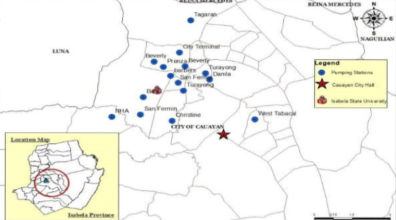
At present, Cauayan has a total fifteen (15) water pumping stations and eight (8) elevated water tanks serving only 12,067 households (29%) out of 30,207 households (71%). The combined distribution efficiency of these water infrastructures under the management and supervision of the Cauayan City Water District (CCWD) is only 87% which is accounted from the 9,229.63 m3 of metered water out of the distributed water of 10,518.13 m3 daily or with a combined distribution losses of 10% which is 1282.50m3 losses per day, ( Alvarez M. S. et.al., 2020). The said study suggests the necessity to introduce new and innovative water management technologies and systems adapted to climate change to addressed the need of the city like; improve the performance of the existing water infrastructure systems, lack of management tool for more efficient delivery of water services, limited service coverage of the water district due to limited water resource and depletion and contamination of aquifers and other water sources since shallow aquifer are mainly utilized. Hence, a GIS-based decision support tool in managing urban water infrastructure with storm water invention is a proposed solution to address the need of the city.
In order to maximize and properly utilize water infrastructure, the integration of decision support systems (DSS) and geographic information systems (GIS) is needed to provide the necessary spatial database for transforming a simple spatial query and visualization tool into a powerful analytical and spatially distributed modeling tool (Satti, S.R., et.al. 2004). Reitsma (1996) define a DSS for water resources applications as computer-based systems which integrate state information, dynamic or process information, and plan evaluation tools into a single software implementation. One of the tools that can be used as DSS is the MIKE Operation. It is a complete GIS-integrated modelling tool that enables users to make sound decisions and create future concepts for urban stormwater systems – concepts that are cost-effective as well as resilient to change (https://www.mikepoweredbydhi.com).
Objectives
The general objective of this study is to develop a management tool for urban water infrastructure to help decision makers, policy makers and managers in Cauayan City, Isabela. The specific objectives are the following:
- To conduct assessment and perform risk analysis of urban water infrastructure systems in Cauayan City;
- To develop decision support tool for effective management of water infrastructure; and
- 3. To design, construct and evaluate urban storm water storage system equipped with monitoring sensors.
Outputs
Publications
Patent/IP
Products
People Services
Places and Partnerships
Policy
Beneficiaries
- LGU Cauayan City
- Students from SUCs/HEIs taking up Engineering Courses
- Laundry businesses
Stormwater Infrastructure Systems
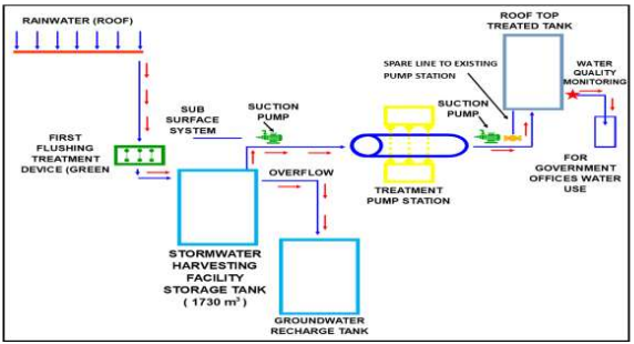
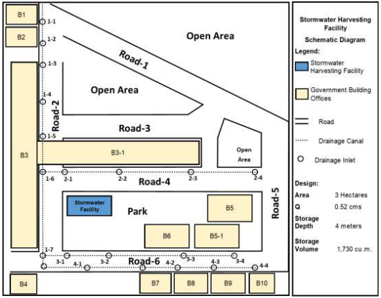
The stormwater water intervention facility has a total catchment area of 3 hectares with a storage capacity 1750 cubic meter. Figure 5 shows the schematic diagram of the proposed stormwater infrastructure system with the different components (i.e. Flushing treatment device, storage tank, groundwater recharge tank, UV treatment , suction pumps , elevated tank, water quality monitoring system and valves and pipings).The recommendation to consider runoff water from the surface/roads aside from rainwater/stormwater falling from the roof is not feasible because the design storage capacity of the stormwater is limited only to one (1) hour rainfall duration which is enough to fill the storage tank. On the other hand, elevating the water storage tank in the proposed design and system is very much appreciated. However, the said recommendation is not feasible considering that the building structures in the proposed site were not uniform in terms of number of storey (I.e. BJMP and PNP buildings are 4 storey buildings while others are two storey and one storey buildings). Elevating the storage tank with this physical condition still needs motor pumps and also requires heavy foundation structures. In addition, the space of the proposed site had limited space. Hence, the space occupied by the proposed subsurface storage tank when covered will be useful for other purposes. Nevertheless, the recommendations will still be considered as a possible option when scaled up to other areas.
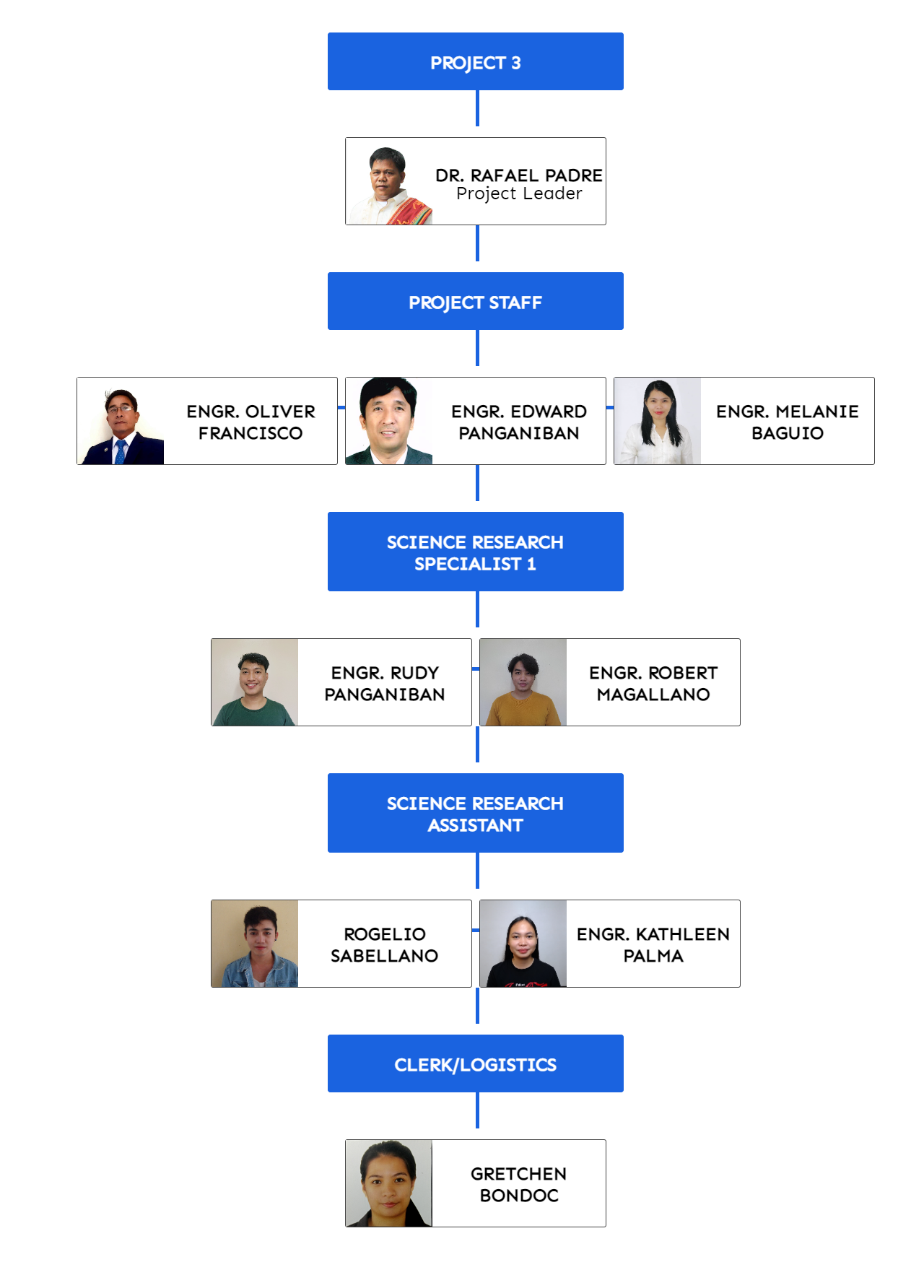
Organizational Chart